
What can I use Enquiry Service for
Phase one of the PlanBuild Tasmania portal - the Enquiry Service is now live for public use. The Enquiry Service allows anyone to enter an address in the portal to see what planning zones and codes apply to a property. A Property Report can be generated which includes maps, details of the planning zone, codes and other information that affect the selected property.
For those properties that fall under the Tasmanian Planning Scheme, PlanBuild Tasmania provides a comprehensive Guided Enquiry service, including identifying planning, building and plumbing rules that may apply to a proposed project.
You will be able to work through a series of questions on your proposed project resulting in information on:
- who to consult (e.g. local council, Heritage Tasmania)
- who can do the work (e.g. a licensed builder)
- what to apply for (e.g. a permit).
After completing an enquiry if you have additional questions or want to request advice from a council, this can be lodged online using PlanBuild Tasmania.
For those properties located in a municipality with an Interim Planning Scheme in operation, the Guided Enquiry service is not available, however you can generate a Property Report. The Property Report will include maps and details of the planning zone, codes and other information that affect the selected location, including whether it is listed on the Tasmanian Heritage Register, Crown land or Council land. Councils also may manage particular local information, such as local heritage places, flood maps and storm water information, which may affect development on the property. You should contact the relevant council for advice as to how these and other features may affect your proposed project.
You can contact the relevant council using the Request Advice service in the portal. Once the Tasmanian Planning Scheme is in effect in a municipal area, you can use the PlanBuild Tasmania Guided Enquiry service to find out more information.
Read more about PlanBuild Tasmania and future functionality.
Why would I complete an Enquiry
You may need to apply for a permit or other type of approval before you start a project. If work is started before approval is granted it may be deemed illegal.
You can use the PlanBuild Tasmania Guided Enquiry service to help identify which approvals may be required for your proposed project.
Learn more about what may happen if you start a project without appropriate approval.
How to use Enquiry Service
You can view and download a PDF copy of the user guide for detailed information on each step of an enquiry.
The first step is shown on this page.
How to search for a property
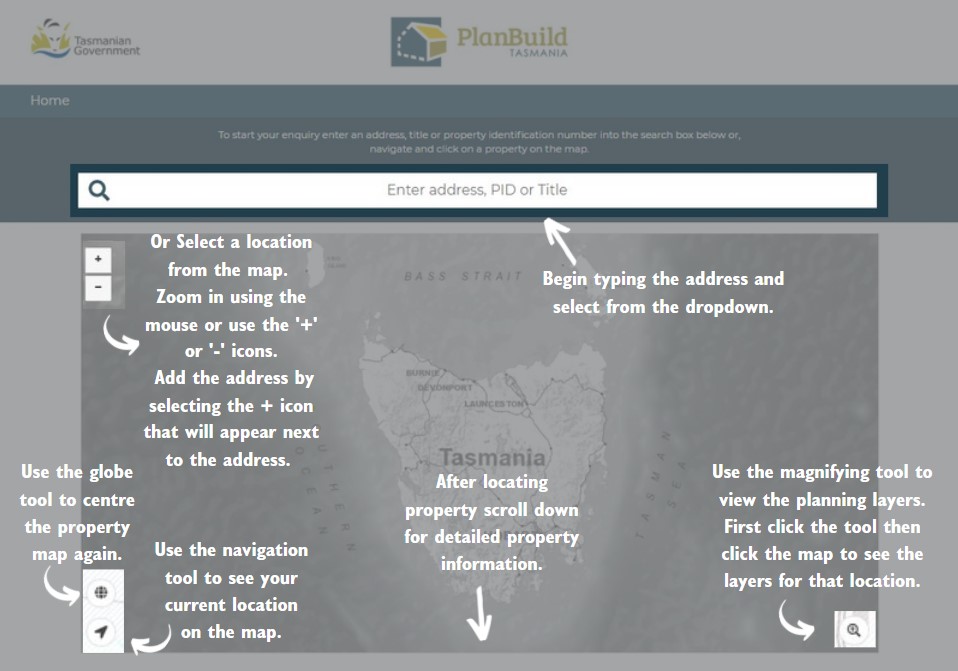
Ready to start an enquiry? Select the Start enquiry button at the top of the page to get started.
Common terms
Below is a list of common terms used in the Guided Enquiry service.
You can view more Frequently Asked Questions about the planning, building and plumbing process.
What is a Zone?
A council will have the Tasmanian Planning Scheme or an Interim Planning Scheme in effect. The planning scheme that applies to a council area, divides the land into zones. Each zone has a particular use for the land (purpose) and sets out the primary controls for the use or development of that land. This information describes if a planning permit is required and the matters that the council must consider before deciding to grant a permit. Examples of zones are General Residential, Open Space and Central Business.
The Tasmanian Planning Scheme has 23 generic zones. Each zone indicates what land use and development is appropriate for that zone.
The Tasmanian Planning Scheme provides for housing across 14 zones. The three main residential zones include the General Residential Zone, Inner Residential Zone and the Low Density Residential Zone. The General Residential Zone is the common residential zone in urban areas. It provides for a range of housing types in areas where full infrastructure services, such as reticulated (network of pipes) water and sewerage systems, are available.
Read more about the Tasmanian Planning Scheme.
What is a Code?
A council will have the Tasmanian Planning Scheme or an Interim Planning Scheme in effect. The planning scheme that applies to a council area includes a list of codes that apply in that area. A code provides controls and clear pathways for dealing with land use issues.
Examples of codes are bushfire prone area, landslip hazard, local heritage, parking requirements and the protection of road, railway and electricity infrastructure. These land use issues can occur across Tasmania and may apply across a range of zones.
What is a Planning or Code Overlay?
A code provides clear pathways and controls for dealing with land use issues, such as bushfire prone areas and coastal erosion hazards. The code overlay is a map that shows the area where this land use issue applies.
What is a Planning Permit?
A Planning permit is a statutory licence issued by a planning authority, usually valid for a specified period, to carry out approved subdivision and/or land development work.
What is a Building Permit?
A Building permit is a statutory licence issued by a permit authority, usually valid for a specified period, to carry out approved building work.
What is a Permit Authority?
A Permit Authority is a licensed person who can grant a permit under the Building Act 2016. A General Manager of a council must appoint a person as a permit authority for that municipal area for that council .
What is an Approved Form?
Approved Forms are used for an application or other document (e.g. A certificate or notice) to meet relevant legal requirements. A full list of Approved Forms can be found on the Consumer, Building and Occupational Services website.
What is an Outbuilding?
An outbuilding is a detached building such as a carport, private garage, shed or similar structure.
What is a Habitable Space?
A habitable space or room is a room used for normal domestic activities, these include a bedroom, living room, lounge room, music room, television room, kitchen, dining room, sewing room, study, playroom, family room, home theatre and sunroom.
What is a Non-habitable Space?
A non-habitable space or room is a room that is occupied neither frequently nor for extended periods. These include a bathroom, laundry, water closet, pantry, walk-in wardrobe, corridor, hallway, lobby, photographic darkroom, clothes-drying room, and other spaces of a specialised nature.
What is a Municipality?
Municipalities are regions of land/geographical area divided for the purpose of defining local government areas, Tasmania is divided into 29 municipalities. Each municipality is represented by a council, as set out in the Local Government Act 1993
Under the Act, Tasmanian councils have three very broad functions, namely:
- to provide for the health, safety and welfare of the community
- to represent and promote the interests of the community
- to provide for the peace, order and good government of the municipal area.
In performing these functions, councils must consult, involve and be accountable to their residents and ratepayers.
Local Government (Councils) as planning authorities are responsible for assessing planning applications, also known as development applications, and issuing planning permits, if approved.
Councils also employ permit authorities who are people licensed to issue building, plumbing and associated permits for that municipality.
For building and plumbing work, you can find more definitions under the National Construction Code. If you come across a term you are unfamiliar with you can search it in the National Dictionary of Building and Plumbing Terms.
Acronyms
PlanBuild Tasmania have tried where possible to not use any acronyms throughout the portal, however in the external links and during the planning, building and plumbing process you may come across some of the acronyms listed below.
- AHT - Aboriginal Heritage Tasmania
- BA – Building Application
- BAF - Building Administration Fee
- CBOS - Consumer, Building and Occupational Services
- CCW - Certificate for Certifiable Work
- CLC - Certificate of Likely Compliance
- CoO - Certificate of Occupancy
- CoT - Certificate of Title
- CRD - Certificate of the Responsible Designer
- DA – Development or Planning Application
- BYDA - Before You Dig Australia
- DoH - Department of Health
- DPAC - Department of Premier and Cabinet
- EHO - Environmental Health Officer
- EPA - Environmental Protection Agency (Tasmania)
- GIS - Geographic Information System
- HT - Heritage Tasmania
- IPS - Interim Planning Scheme
- LGA – Local Government Area
- LGAT - Local Government Association Tasmania
- LIST - Land Information Systems Tasmania (LISTmap)
- LPS – Local Provisions Schedule
- LTO - Lands Titles Office
- LUPAA - Land Use Planning and Approvals Act 1993
- NCC - National Construction Code
- NPR - No Planning Permit Required
- NRE - Department of Natural Resources and Environment Tasmania (formerly DPIPWE)
- OLAC - Occupational Licensing and Accreditation
- PID – Property Identification Number
- PPU - Planning Policy Unit
- RFI - Request for Information
- SPP - State Planning Provisions
- TFS - Tasmanian Fire Service
- TPC - Tasmanian Planning Commission
- TPS – Tasmanian Planning Scheme
- TRN – Title Reference Number